According to the National Weather Service, the hottest weather of 2022 will be experienced this week with a Heat Advisory in effect for the entire region through Wednesday. Record high temperatures could be felt this week as the mercury inches toward triple digits.
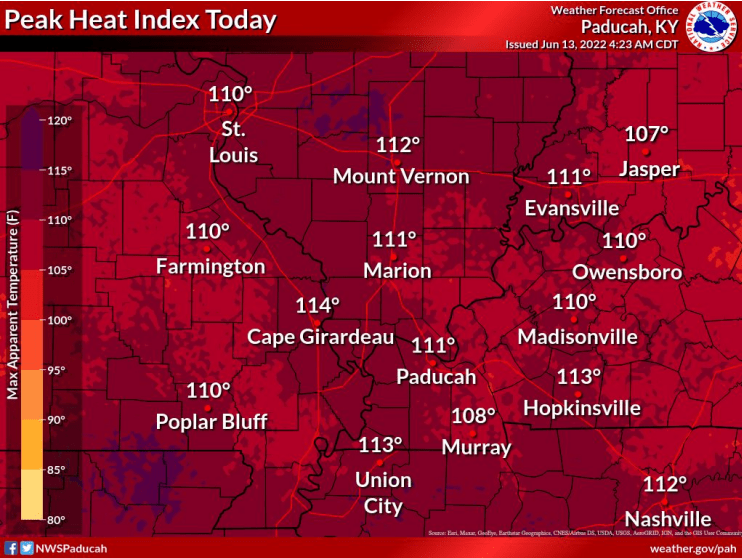
The weather services calls it a rare and dangerous combination of heat and humidity today. With dew point temperatures in the middle to upper 70s, they expect it to yield widespread heat index values of 108 to 114 degrees.
Record high temperatures for Hopkinsville as recorded by the National Weather Service dating back to 1896 show a record high of 99 degrees on this date in 1953. Tuesday’s record high is 98 degrees in 1963 and Wednesday is 101 degrees in 1952.
Making this week’s hot weather even odder is that Sunday’s high of 91 degrees marked the first time this year the mercury topped 90 degrees. The latest date on record for the latest 90-degree day was June 24, 2003.
As temperatures escalate this week, one must be prepared for heat safety measures — and understand the symptoms of heat exhaustion or heat stroke. Dizziness, excessive sweating, clammy skin, nausea and vomiting, a rapid weak pulse, and muscle cramps are all signs that someone is succumbing to heat exhaustion. Heat stroke is far more severe and is often diagnosed following throbbing headaches, no sweating, a body temperature of 103 degrees, red hot dry skin, excessive nausea and vomiting, a rapid strong pulse, and loss of consciousness.
If one must be outside throughout this week, spend considerable time in cooler conditions, drink plenty of water, take cool showers if overheated, wear light and reflective materials and use frequent breaks in activities.